Ross Sea Region Soil Sites
571000
571
20-Jan-1990
IBC, GGGC, MRB
Marble Point region, western McMurdo Sound just east of the Wilson Piedmont Glacier, between Marble Point and Gneiss Point
Permafrost and soil moisture investigations
Marble Point Quadrangle, US Geological Survey, 1975
CS Pro & Lscp
Yes
163.6770
-77.4203
77deg 25.22'S
-163deg -40.62'E
cf. Notes for DESCR below
0
Nil
75
cf. Notes for GEOLAND below
Oceanic subxerous, dry surface horizon but moist beneath
-18
Coastal Antarctic
Greyish sandy gravel over layered brownish slightly sticky till
Nil observed at site
Nil
| SURFACE WEATHERING or |
| SURFACE FEATURES |
A disturbed surface without pavement development
Ground scraping for construction fill
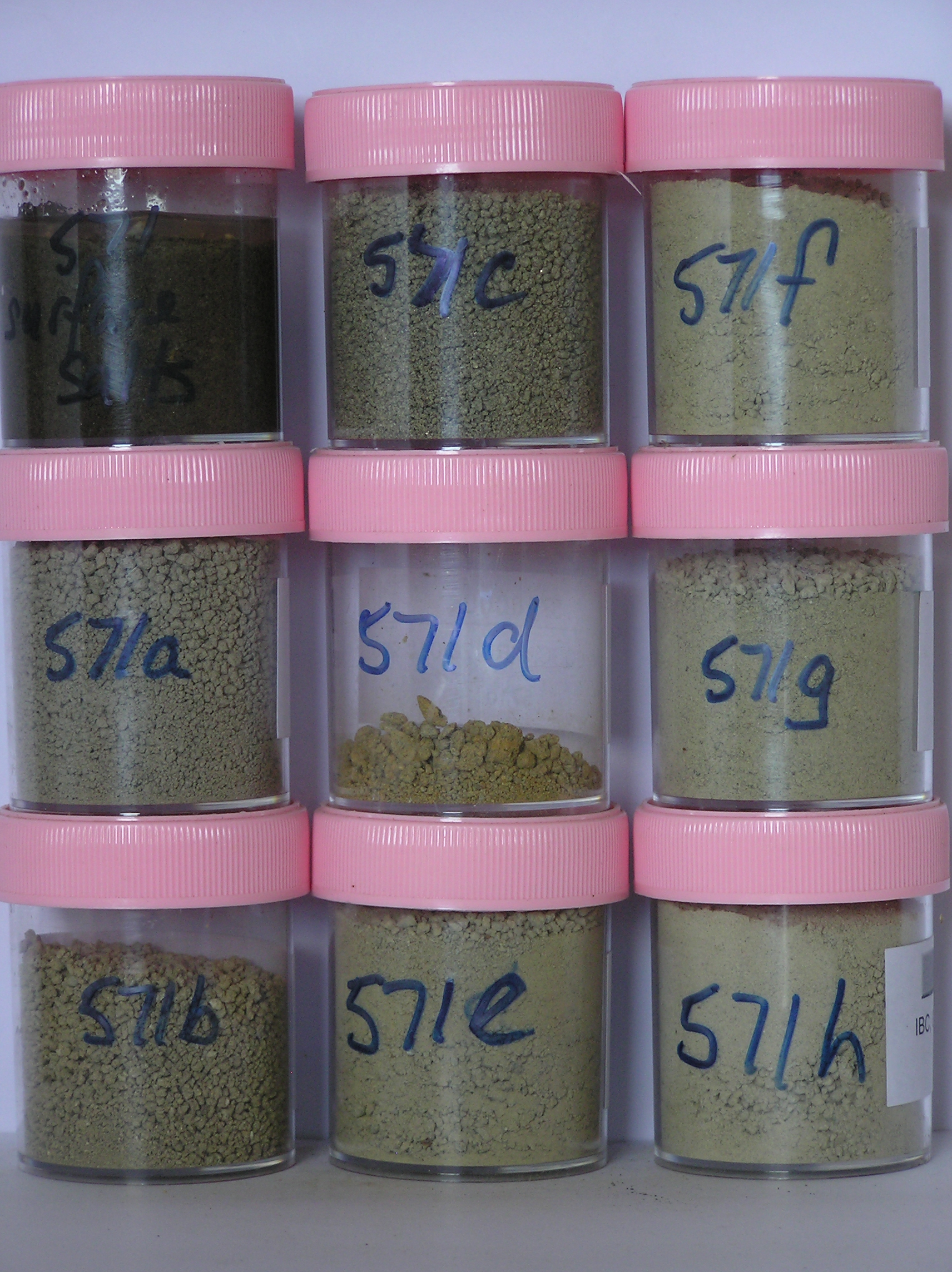
571a 0-29cm
101
light brownish grey (2.5Y 6/2) sandy to silty gravel
102
moderately cohesive
103
rock particles angular and unstained
104
sharp boundary
105
571b 29-35cm
201
| light yellowish brown to light olive brown (2.5Y 6/4 - 2.5Y 5/6) sandy to silty gravel forming a thin |
| interfingered lens |
202
slightly sticky
203
rock particles angular and unstained
204
sharp boundary
205
571c 35-38cm
301
olive grey (5Y 5/2) sandy to silty gravel forming a thin interfingered lens
302
rock particles angular and unstained
303
sharp boundary,
571d 38-39cm
401
brownish yellow (10YR 6/8) sandy gravel forming a thin intermittent layer
402
sharp boundary,
571e 39-46cm
501
light grey (5Y 7/2) sandy to silty gravel
502
slightly sticky
503
sharp boundary,
571f 46-58cm
601
pale olive (5Y 6/3) sandy to silty gravel
602
moderately cohesive and slightly sticky
603
sharp boundary, drill core in ice-cemented ground
571g 58-73cm
701
[ pale olive (5Y 6/3) silty gravel,
571h 73-79cm
801
[
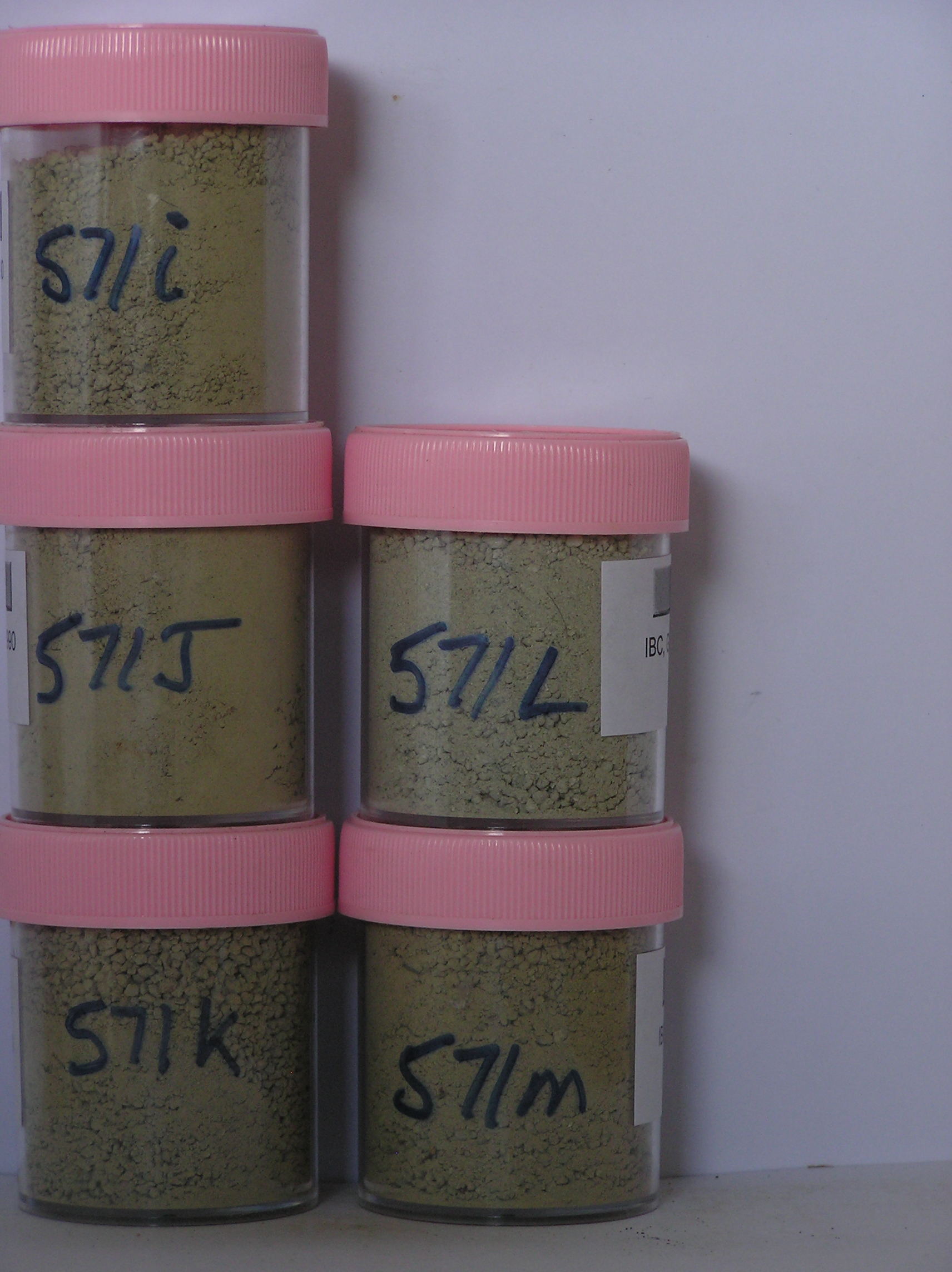
571i 79-96cm
901
[
571j 96-105cm
1001
[
571k 105-115cm
1101
[
571l 115-132cm
1201
[
571m 132-152cm
1301
[
Yes
A-M
A-M
Ice-cemented
58
1
(58cm)
Descr
| About 50m from the western side of the old runway, towards the northern end on a surface which has been cut and scraped for construction materials, an uneven |
| surface with linear cut and sidecast ridges; the surface forms a hollow, about 75cm below original ground surface and probably accumulates some thaw water at |
| times |
Geoland
| The land surface is a gently undulating till plain formed by retreat of the Wilson Piedmont Glacier; the Marble Point region is an old landscape, as evidenced by |
| deposits of phillipsite, buried soils and oxidised gneiss, which have been covered by advances of the grounded Ross Ice Shelf; later ice retreat and glaciological |
| features have been controlled by changes in the stranded Wilson Piedmont Glacier; the till mantle is patchy and dominated largely by locally occurring rocks |
| Soluble Salt |
| Concentration |
57100001
571a
0-29cm
0
29
59.00
6.50
none
57100002
571b
29-35cm
29
35
78.00
16.50
none
57100003
571c
35-38cm
35
38
33.00
6.70
none
57100004
571d
38-39cm
38
39
none
57100005
571e
39-46cm
39
46
45.00
11.20
none
57100006
571f
46-58cm
46
58
79.00
17.00
none
57100007
571g
58-73cm
58
73
32.00
6.90
none
57100008
571h
73-79cm
73
79
39.00
9.90
none
57100009
571i
79-96cm
79
96
48.00
15.10
none
57100010
571j
96-105cm
96
105
47.00
10.90
none
57100011
571k
105-115cm
105
115
49.00
12.60
none
57100012
571l
115-132cm
115
132
74.00
16.60
none
57100013
571m
132-152cm
132
152
54.00
20.00
none
57100001
59.00
25.90
16.70
19.40
13.10
8.70
9.10
6.70
0.30
6.50
57100002
58.00
14.60
10.90
13.70
11.50
15.60
19.30
14.10
0.30
16.60
57100003
33.00
42.50
17.40
12.90
8.20
9.50
6.70
2.60
0.10
6.70
57100004
40.90
12.10
11.90
9.40
11.10
10.00
3.60
1.00
57100005
45.00
27.30
11.90
12.00
8.30
11.20
15.90
12.80
0.50
11.20
57100006
79.00
17.20
12.60
15.30
12.40
17.00
17.50
7.80
0.20
17.00
57100007
32.00
27.00
14.90
15.60
10.20
11.40
12.60
7.90
0.30
6.90
57100008
39.00
27.10
12.20
13.00
10.00
13.90
15.40
8.30
0.20
9.90
57100009
48.00
24.80
13.10
13.90
10.20
12.80
15.40
9.60
0.20
15.10
57100010
47.00
29.80
11.60
13.90
9.50
12.40
14.30
9.90
0.50
10.90
57100011
49.00
26.50
10.80
11.00
8.70
11.30
17.50
13.70
0.40
12.60
57100012
74.00
24.30
14.50
16.60
11.70
12.60
13.10
7.10
0.10
16.60
57100013
54.00
25.00
12.00
12.80
9.70
12.10
16.10
12.00
0.40
20.00
57100001
9.50
1.06
4.60
0.10
0.10
0.10
2.50
0.60
0.07
57100002
8.70
1.60
6.00
0.40
0.40
0.20
3.90
0.40
0.16
57100003
8.60
0.98
3.00
0.50
0.60
0.10
2.50
0.40
0.05
57100004
8.40
2.80
3.30
0.40
0.60
0.10
3.20
0.30
0.12
57100005
8.20
1.40
9.70
0.60
0.80
0.40
7.50
0.30
0.03
57100006
9.00
1.36
2.70
0.50
0.12
57100007
9.20
1.10
5.00
0.02
0.10
0.10
2.70
0.50
0.12
57100008
8.90
1.44
6.10
0.06
0.10
0.10
3.50
0.60
0.12
57100009
8.90
1.70
6.90
0.07
0.10
0.10
4.20
0.50
0.06
57100010
8.80
1.55
6.60
0.10
0.20
0.10
4.10
0.50
0.03
57100011
8.50
2.20
8.00
0.40
0.70
0.30
6.00
0.40
0.08
57100012
8.60
1.24
3.60
0.40
0.90
0.10
3.30
0.40
0.14
57100013
8.40
3.00
9.80
0.70
1.20
0.40
8.00
0.30
0.05
57100001
45
10
20
10
15
57100002
10
10
80
57100003
2
4
90
4
57100004
3
5
90
2
57100005
5
5
90
57100006
5
5
90
57100007
45
45
50
5
57100008
5
5
20
10
60
57100009
5
5
5
85
57100010
10
20
70
57100011
15
15
70
57100012
20
20
60
57100013
5
5
90
12-Dec-2005
Page 529 of 896
571