| Funder | Collaborators | Duration |
|---|---|---|
| Ministry for the Environment (MfE) |
0 years 4 months
Start date: 01 Jan 2019 End date: 31 May 2019 |
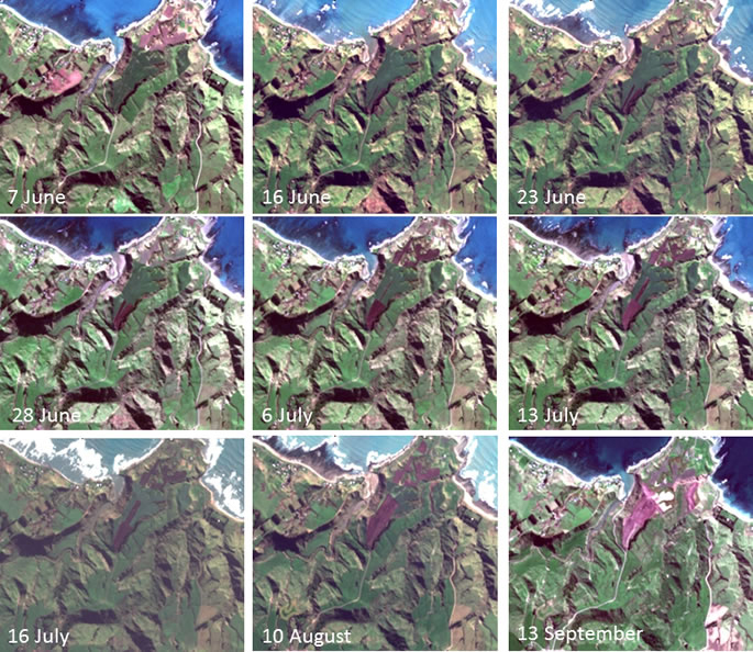
Using recently developed methods for automated cloud clearing to temporally analyse Sentinel 2 imagery
Winter forage cropping and grazing practices in New Zealand hill country can result in severe de-vegetation and erosion, and therefore have a significant negative impact on downstream water quality. Research has shown that sediment and nutrient losses from winter-grazed hill country pasture are greater with increased slope and increased percentage of bare ground associated with soil damage from treading.
The Ministry for the Environment (MfE), as part of the Essential Freshwater policy development process, engaged Manaaki Whenua – Landcare Research (MWLR) to assess the spatial extent of hill country forage cropping and intensive grazing, as well as the severity and timing of de-vegetation that results from these practices.
The work, as part of the Advanced Remote Sensing Aotearoa (ARSA) programme, used recently developed methods for automated cloud clearing to temporally analyse Sentinel 2 imagery for the period autumn to spring 2018, and to identify all paddocks with a slope of 7 degrees or greater where winter forage paddocks became bare due to cattle grazing (Figure 1).
Results
The analysis found that over 9,000 paddocks on land over 7 degrees were identified to have gone bare during the 2018 winter and assessed to be at risk of high soil erosion. These paddocks collectively covered an area of 42,082 ha, which is 0.76% of the New Zealand hill country agricultural land with a slope greater than 7 degrees. The regions with the most winter forage cropping, as a percentage of the hill country agricultural land, were Southland (2.21%), Otago (1.61%), and Canterbury (1.20%). The data have also enabled soil erosion scientists to quantify for the first time the national total of soil lost from winter forage cropping on hilly land (>7 degrees) at 689,000 tonnes. Compared with total sediment loads in rivers this is small at ~1%, but it has a high impact on water quality in small streams near winter forage paddocks.