Funder Collaborators Duration
Northland, Waikato, Horizons, Hawke’s Bay, Auckland Council, Environment Southland, Ministry for the Environment, Ministry for Primary Industry, Our Land & Water National Science Challenge, and Federated Farmers NIWA, Massey University, Waikato University and international collaborators from KU Leuvin, IRSTEA, University of Salzburg, HAFL Switzerland. Our partners include Whanganui iwi (Tamaūpoko Community Group) and Rangitāne o Manawatū. 4 years 9 months
Start date: 01 Oct 2018
End date: 01 Jul 2023
Hill erosion.

Exploring cost-effective ways of targeting land-based erosion control

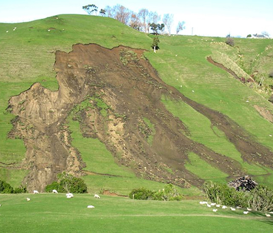
To meet national freshwater objectives for catchment management, regional councils and land managers need higher-resolution data on catchment erosion and sediment delivery to streams, and new tools and models that provide information at appropriate scales. These are essential for efficient and cost-effective erosion and sediment mitigation, and will also assist planning for predicted increased storminess as a result of climate change.

The NZ landscape is characterised by a complex array of erosion processes with high spatial and temporal variability, which provides a challenging environment for process-based erosion and sediment science and modelling. Our research will address global research questions and put NZ at the forefront of international research by significantly improving understanding of:

  • spatial and temporal patterns of erosion
  • sediment-related water quality
  • sediment mitigation performance
  • model refinement (e.g. from average annual to storm-event scale)
  • the economic analysis of erosion and sediment mitigation.

A 5-year MBIE funded programme Smarter Targeting of Erosion Control is now well underway, exploring cost-effective ways of targeting land-based erosion control in the hope of slowing the damage and improving water quality. The programme is led by Manaaki Whenua – Landcare Research in collaboration with NIWA, Massey University, Waikato University, international researchers, programme partners Whanganui iwi (Tamaūpoko Community group) and Rangitāne o Manawatū, as well as several regional councils.

Research is focusing on four catchments across New Zealand: the Manawatu – for new and continuing data collection; the Whanganui – to investigate impacts from the 2018 storm and legacy sediments; and the Oreti in Southland and Wairoa near Auckland – to research storm event sediment loads and sediment source fingerprinting methods in collaboration with NIWA’s Managing Mud programme.


Contact details

Hugh Smith
Manaaki Whenua - Landcare Research, Palmerston North, New Zealand

P: +64 6 353 4809
Email Hugh

Publications & outputs

Journal papers

Spiekermann R.I., Smith H.G., McColl S., Burkitt L., Fuller I.C. 2022. Quantifying effectiveness of trees for landslide erosion control. Geomorphology 396: 107993. DOI: 10.1016/j.geomorph.2021.107993

Basher L, Spiekermann R, Dymond J, Herzig A, Hayman E, Ausseil A-G 2020. Modelling the effect of land management interventions and climate change on sediment loads in the Manawatū–Whanganui region. New Zealand Journal of Marine and Freshwater Research. DOI: 10.1080/00288330.2020.1730413

Davies-Colley R, Hughes A 2020. Sediment-related water quality of small hillcountry streams near Whatawhata, New Zealand. Response to integrated catchment management (ICM). New Zealand Journal of Marine and Freshwater Research, DOI:10.1080/00288330.2020.1761840

Gasser E, Perona P, Dorren L, Phillips C, Hubl J, Schwarz M 2020. A new framework to model hydraulic bank erosion considering the effects of roots. Water 12: 893. DOI: 10.3390/w12030893  24p.

McIvor I, Marden M, Douglas G, Hedderley D, Phillips C 2020. Influence of soil type on root development and above- and below-ground biomass of 1-3 year-old Populus deltoides x nigra grown from poles. International Journal of Environmental Sciences & Natural Resources 24(3). DOI: 10.19080/IJESNR.2020.23.556138

Vale S, Dymond J 2019. Interpreting nested storm event suspended sediment-discharge hysteresis relationships at large catchment scales. Hydrological Processes 2019: 1-21. DOI: 10.1002/hyp.13595 .

Reports and posters

Gasparini I 2019. Mechanical properties of "Tasman" poplar roots: measurement and modeling. Case study at Ballantrae Hill Country Research Station. Mountain Forests and Natural Hazards. Bern University of Applied Sciences – BFH. School of Agriculture, Forest and Food Sciences HAFL.

Herzig A, Zoerner J, Dymond J, Smith H, Phillips C 2020. An Interoperable Low-Code Modelling Framework for Integrated Spatial Modelling (https://presentations.copernicus.org/EGU2020/EGU2020-20868_presentation.pdf ) Presentation at EGU online May 2020.

Neverman AJ, Basher L, Spiekermann R, Dymond J, Fragaszy S 2019. A catchment-scale modelling framework to test the feasibility of land management scenarios for achieving proposed sediment attribute bottom lines. NZ Hydrological Society Conference 3-6 December 2019, Rotorua. Poster & abstract.

Phillips C, Basher L, Spiekermann R 2020. Bio-physical performance of erosion and sediment control techniques in New Zealand: a review. Manaaki Whenua - Landcare Research Contract report prepared for MBIE as part of STEC programme.

Plaschy J 2019. Root distribution of the ‘Tasman’ poplar in New Zealand pastoral hillcountry. From the root distribution of single trees to the model of the stand reinforcement. Bachelor’s dissertation, unpublished. Mountain Forests and Natural Hazards. Bern University of Applied Sciences – BFH. School of Agriculture, Forest and Food Sciences HAFL.  48p.

Smith H 2020. A region-wide assessment of shallow landslide susceptibility in Hawke's Bay. Manaaki Whenua - Landcare Research Contract Report LCLC3720 for Hawkes's Bay Regional Council.

Smith HG, Spiekermann R, Dymond J, Basher L 2019. Predicting spatial patterns in bank erosion for catchment sediment budgets in New Zealand. NZ Hydrological Society Conference 3-6 December 2019, Rotorua. Poster & abstract.

Smith HG, Vale S, Swales A, Woodward B, Olsen G 2019. Tracer selection and source discrimination for geochemical sediment fingerprinting. NZ Hydrological Society Conference 3-6 December 2019, Rotorua. Poster & abstract.

Smith H, Spiekermann R, Herzig A, Dymond J 2020. Application of a revised bank erosion model to update SedNetNZ results for Hawke’s Bay. Landcare Research Contract Report LCLC3740 for Hawkes's Bay Regional Council.

Spiekermann R, McCavana B, Hudson K, Phillips C, McIvor I, Boone D 2020. How effective are space planted poles at reducing shallow landslides? NZARM Broadsheet Issue 34, March 2020, 9-10.

Vale S, Smith H 2019. Quantifying sources of overbank sediment deposits in the lower Oroua: sediment fingerprinting. NZ Hydrological Society Conference 3-6 December 2019, Rotorua. Poster & abstract.