Data sources and reports
The Ross Sea Region data on this site is taken from the following sources:
Data
Soil studies by Iain Campbell, Graeme Claridge, and their colleagues over 35 years have been organised into the soils reports accessible from this part of the website. You can also view the soil sites using an interactive map viewer.
This is a 'point' database containing descriptions of over 1,000 soil pits, together with their chemical, physical, and mineralogical characteristics, at soil sites clustered around ice-free areas. Site descriptions include observations of the surrounding geological, topographic and climatic contexts, and local surface features, site moisture, parent material and biology.

The SCAR Composite Gazetteer of Antarctica (CGA) has been compiled over a period of 29 years (commenced 1992) and consists of 39,007 names that correspond to 20,105 features. The place names information has been submitted by the national names committees from 22 countries and compiled by Roberto Cervellati and Chiara Ramorino from the Italian Antarctic names committee - Comitato per i nomi geografici antartici.
The SCAR CGA is a relational database - related to the SCAR Map catalogue, SCAR Feature Catalogue and the SCAR Flora and Fauna databases (all developed by the Australian Antarctic Data Centre). This allows the search for Antarctic names, maps and flora and fauna information to be addressed via the gazetteer or map catalogue with results showing links to national names committees, map publishers, map retailers and small scale maps showing the distribution of flora and fauna.
Vector data from the SCAR Antarctic Digital Database (ADD) managed by British Antarctic Survey have been downloaded from their website.
The ADD is a seamless compilation of topographic data for Antarctica to 60°S. The ADD is the place to view, query and download topographic datasets such as the Antarctic coastline, contours and rock outcrop.
British Antarctic Survey (BAS) compiles, manages and distributes the ADD datasets on behalf of SCAGI, the SCAR Standing Committee on Geographic Information.
ADD datasets and data access
Visit the Antarctic Digital Database map viewer to visualise the available data. Data can be downloaded through the data catalogue in Geopackage or Shapefile format.
Datasets
The datasets included in the ADD are:
- Coastline, including grounding lines and ice shelf fronts
- Rock outcrop
- Contours
- Lakes
- Moraine
- Streams
- Seamask
- ADD data limit at 60°S
All datasets are in WGS84 Antarctic Polar Stereographic projection, EPSG 3031.

A quadrant of the 1.6GB medium resolution version of the Radarsat-1 Antarctic Mapping Project (RAMP) SAR mosaic was extracted and downloaded for use from the National Snow & Ice Data Centre.
The mosaic provides a detailed look at ice sheet morphology, rock outcrops, research infrastructure, the coastline, and other features of Antarctica, as well as representing calibrated radar backscatter data, which may provide insight into climate processes affecting the upper few meters of snow cover.
The high-resolution RAMP Digital Elevation Model (DEM) combines topographic data from a variety of sources to provide consistent coverage of all of Antarctica.
The following products are available:
- A 125 m resolution Version 2 mosaic is available via HTTPS as a flat binary file accompanied by a descriptive README file.
- The 25 m resolution Version 2 images and ancillary data comprise approximately 90 separate tiles. Each 25 m resolution tile is composed of many sub-tiles which must be assembled into the tile image. Tiles are packaged with the necessary tools and with a variety of ancillary information, including surface elevation and information about the original swath data used to create the mosaic. README files are included in each tile’s directory.
- 200 m, 500 m, and 1 km resolution Version 2 GeoTIFF images are available via HTTPS.

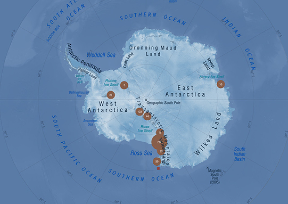
Soils Map Viewer - Ross Sea Region soils sites
View site locations for the Ross Sea Region Soils Database.

Access to databases
Publications
Bockheim JG, McLeod M. 2006. Soil formation in Wright Valley, Antarctica since the Late Neogene. Geoderma 137: 109–116.
Bockheim JG, McLeod M. 2008. Soil distribution in the McMurdo Dry Valleys, Antarctica. Geoderma 144: 43–49.
Bockheim JG, Campbell IB, McLeod, M. 2008. Use of soil chronosequences for testing the existence of high-water-level lakes in the McMurdo Dry Valleys, Antarctica. Catena 74: 144–152.
Campbell IB, Claridge GGC. 1987. Antarctica: soils, weathering processes and environment. Elsevier, Amsterdam. 368p.
Hofstee EH, Balks MR, Petchey F, Campbell DI. 2006. Soils of Seabee Hook, Cape Hallet Northern Victoria Land, Antarctica. Antarctic Science 18: 473–486.
Gibb RG, Campbell IB, Claridge GGC. 2002. 35 years of Ross Sea region soil studies on-line. Third International Conference on Contaminants in Freezing Ground, Hobart 14–18 April 2002.
McLeod M, Bockheim JG, Balks MR. 2008. Glacial geomorphology, soil development and permafrost features in central-upper Wright Valley, Antarctica. Geoderma 144: 93–103.
McLeod M, Bockheim J, Balks M, Aislabie, J. 2009. Soils of western Wright Valley, Antarctica. Antarctic Science 21: 355–365.