Soil survey - the basics
Soil survey or soil ‘mapping’ is the systematic examination, description, classification, and mapping of soils in a given area.
Soils are dynamic natural bodies, and they are surprisingly diverse! A soil survey enables us to capture this diversity, analyse the relationship of soils with their environment, and understand their distribution in the landscape.
Typical contexts for soil survey are e.g. land use planning, irrigation suitability assessment, effluent disposal, drainage works, or urban development.
A ‘ground-truthing’ survey is required in these cases, as soil properties vary across the landscape and these variations will influence how an area is managed and will perform. The soil information generated during a soil survey is a fundamental requirement in the management of both agricultural productivity and environmental outcomes.
Demand is predominantly being driven by the needs to increase New Zealand’s agriculture primary product exports, while minimising the loss of non-point source contaminants from agricultural land to fresh water, and conserving the soil resource and soil quality in the long term.
A wide range of techniques and data sources is used to conduct a soil survey. Usually, a soil survey comprises an initial desktop review of available information, followed by field observations, and finally computer-based delineation of soil survey units and map delivery. Predicting or ‘modelling’ can also play a role, especially when trying to cover larger survey areas.
The desktop study checks on relevant historic soils information, as well as associated environmental factor maps that describe the geology, climate, topography, and land use, that all interact to form soil.
The field survey is conducted using hand-held augers allowing soil descriptions to a maximum depth of 1m. Common soil properties captured from an auger are soil horizons, texture, structure, colour and soil type. Soil pits can be used for more detailed characterisation of ‘typical’ soil properties. Soil sampling is a standard part of any soil survey; laboratory analyses allow insights into chemical and physical properties which cannot be easily observed in the field. They also help to confirm the preliminary soil classification made while in the field.
Bringing environmental factor data, auger point and/or soil pit information and lab analyses together will allow the soil scientist to identify areas in the landscape where soil formation processes – and thus soil characteristics – are similar. These areas of similarity define the map units. By combining all the different map units, a soil map is created.
Today, modern Geographic Information Systems (GIS) and geostatistical methods improve our ability to detect relationships between soils and the other environmental factors in the landscape. This contributes to better soil maps.
Observations made in the field in the form of soil auger or pit descriptions are secured in our National Soil Data Respository (NSDR). The same is for any soil analytical information generated in the labs.
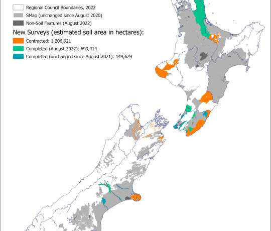
The soil map as the main output of a survey is loaded into S-map Online, our digital soil spatial information system for New Zealand. Soil maps can be explored from there, and soil factsheets downloaded for any location of interest.
Depending on the type of survey, a survey report might also be available.


