Soil drainage
Soil drainage, in a dynamic sense, refers to the rate and degree of removal of water by surface run-off, flow through the soil to underground spaces, evaporation, and transpiration. In the passive sense, as a condition of the soil, it refers to the frequency and duration of periods when the soil is free of complete or partial saturation.
To assess the condition of drainage at any particular time is relatively simple. The main challenge is to estimate the general, 'cumulative' condition of drainage during a period of time, particularly during the whole year. And to have a field appraisal that does not require continuous measurements of soil water content or water table heights.
Among the internal soil characteristics that throw light on the soil drainage and its variations at different times of the year, are:
- the soil texture; the soil structure
- the pattern of cracking which is evaluated in terms of changes with changing degrees of saturation
- the soil colour
- the pattern of mottling - particularly the distribution of the grey colours accompanying gleying
- the presence and kinds of concretions and pans
- the kind and depth of organic matter
- and other characteristics of the profile which have been shown by local experience to be correlated with drainage.
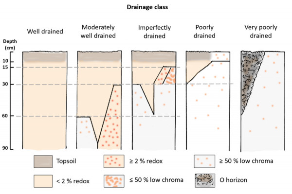
Early NZ drainage classes were modeled after the US Soil Survey example (Taylor & Pohlen 1962, 1979). In the 1990's New Zealand's pedologists were canvassed for drainage class definitions in use in the various NZ regions, and the following 5 drainage Hydromorphic Class 1 (H1): very poorly drainedor 'hydromorphic' classes were established for subsequent use in the NZ Soil Classification (NZSC):
Hydromorphic Class 1 (H1): very poorly drained
Soils that:
- have an O horizon (but no F or H horizon) with an Er, Br, or Cr horizon immediately underlying or
- lack a distinct topsoil and have 50% or more low-chroma colours on cut faces at less than 10 cm from the soil surface
Hydromorphic Class 2 (H2): poorly drained
Soils that have a distinct topsoil and that:
- (a) within 15 cm of the base of the A horizon, or
- (b) within 30 cm of the mineral soil surface, have either 50% or more low-chroma colours on cut faces or dominant on ped faces
or
Soils that have a distinct topsoil and that:
- lack a distinct topsoil and have 50% or more low-chroma colours on cut faces between 10 and 30 cm from the soil surface
Hydromorphic Class 3 (H3): imperfectly drained
Soils that have:
- between the depths of 30 and 60 cm, but not within 15 cm of the base of the A horizon 50% or more low-chroma colours on cut faces or ped faces
or
Soils that have either:
- (a) within 15 cm of the base of the A horizon, or
- (b) within 30 cm of the mineral soil surface
- 2% or more redox segregations, or
- 50% or less low-chroma colours on ped faces or on cut faces.
Hydromorphic Class 4 (H4): moderately well drained
Soils that have a horizon:
- between 60 and 90 cm of the mineral soil surface with 50% or more low-chroma colours on cut faces, or ped faces or
between 30 and 90 cm depth with 2% or more redox segregations.
Hydromorphic Class 5 (H5): well drained
Soils that have no horizon
- less than 90 cm with 2% or more redox segregations
An alternative was developed which uses the diagnostic horizons and features of the NZSC:
Hydromorphic Class 1: H1 as above
Hydromorphic Class 2: H2 Soils that have a gley profile form
Hydromorphic Class 3: H3 Soils that have a mottled profile form
Hydromorphic Class 4: H4 Soils that have either a reductimorphic horizon between 60 and 90 cm, or a redox-mottled horizon between 30 and 90 cm
Hydromorphic Class 5: H5 Soils that do not have a redox mottled horizon at less than 90 cm
In 2020, a simplified field observation key and associated drainage class pictograms were developed. Note that this is a sequential key, and soil drainage class is identified from the first positive result:
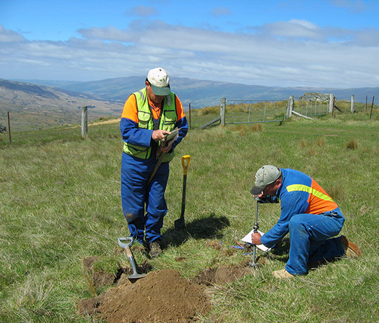
1. Dig a hole to 30 cm
- Is there peat at the soil surface or below?
- Yes = Very poorly drained
Examine the horizontal surface at the base of the hole
- Is the soil colour predominantly grey or blue coloured? Yes = Poorly drained
- Is the soil mottled with rusty colours? Yes = Imperfectly drained
If the answer is NO to the above questions
2. Dig the hole to 60 cm
Examine the horizontal surface at the base of the hole
- Is the soil colour predominantly grey or blue coloured? Yes = Imperfectly drained
- Is the soil mottled with rusty and/or grey colours? Yes = Moderately well drained
If the answer is NO to the above questions
3. Dig the hole to 90 cm
- Is the soil mottled with rusty and/or grey colours? Yes = Moderately well drained
4. If the answer is NO to the above questions
- The answer is Well drained

Drainage class.

